|
Sept
4 , 1983 Sunday (206.4 mtg) From
Gonzo!s Appalachian Trail journal
Everything
in my bowels seemed to have calmed down by this morning when I left
the shelter and began the final mile of trail toward the summit
of Spaulding Mountain. A short side trail could have taken me to
the summit had I chosen to go, but I did not. I began the descent
toward Mount Sugarloaf. In past years, the trail used to go up and
over Sugarloaf, but ski development has caused a relocation around
the mountain so once again the summit is reached only by side trail.
This time I did follow the side trail to the view from the summit
where the ski lift station and snack bar are located. The view was
magnificent! I could see the Crockers that I was about to traverse,
and the Bigalow Range that I would climb the following day.
At
the base of Sugarloaf, a trail crew continued with the construction
of a bridge across the South Branch of the Carrabasset River near
where the trail crossed. It was not finished yet so I had to rock
hop across to the opposite shore from one partially submerged boulder
to the next. As I came upon a segment of the crew cutting trees
to be used on the project, I noticed that two of them were members
of the crew that were building the shelter at Frye Notch. I stopped
a little farther on at the Crocker Cirque Campsite to read the register
and take a break. The lake was beautiful and would have been a nice
place to stay. I moved on to the summit of South Crocker and took
the short side trail to the view. I could just barely see Sugarloaf
across the valley. From there the trail dipped and then went back
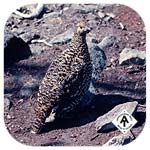
up to the North Summit where I found a family of Spruce Grouse in
a clearing near the top. I observed them for a while and decided
I did not need to eat them - although I was tempted.
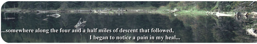
Somewhere
along the four and a half miles of descent that followed, I began
to notice a pain in my heal. Apparently I had bruised it during
the steep downhill from Sugarloaf, but did not notice it until now.
The descent was painful, but I was determined to make the miles
to the road crossing where I could hitch into the town of Stratton,
Maine, where I knew I had a place to stay, resupply, and rest if
the need arrived. I met weekend hikers on their way up to the Crockers.
I could not understand why, the Crockers were not that impressive
to me, with the exception of the campsite. Along the descent I also
caught up with a lady going the same direction as I. Before I got
to a distance where I could talk with her, she noticed me and ran
down the trail as if to escape from the monster that was approaching.
Eventually I caught up with her again, but this time she had caught
up with an older guy, her father I guess. I inquired as to how far
the highway was from this point, and of course they really had no
clue - they had just come from there, why would they know?
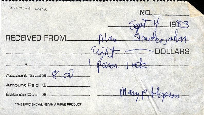
Once at the highway I stuck out my thumb at all passing vehicles.
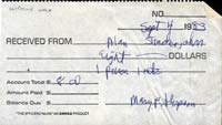
It took a while, but I finally got a ride from a couple of guys
who dropped me off in Stratton right in front of "The Widows
Walk." This fancy Victorian home was a bed and breakfast for
the elite ski crowd in the winter who pay as much as $100 per night,
where as the fee was only $8 per night for the dirty, smelly hikers
in the summer - just like Mountain Meadows near Sherburn Pass in
Vermont. There were three southbounders already there. I selected
a room and got myself cleaned up. Later that day "the Maximus"
showed up and checked in. Then Lan AT Hiker (Susan Parsons) and
Tom came by, but lacking the funds, they decided to go down to the
campground down the road to do laundry, and then returned to camp
out across the street in the back yard of the museum or church.
The four of us went to "Cathie's Place" to have dinner
that night. Most of us opted for the all you can eat salad bar.
 (click on image for larger view)
Gonzo!
Appalachian Trail Journals ©1983
|