|
Aug
14 , 1983 Sunday (504.7 mtg) From
Gonzo!s Appalachian Trail journal
The
first few miles of the day were mostly downhill to Clarendon Gorge
where the Mill River runs through the valley. The trail crosses
the river on a high suspension bridge over the gorge. At the middle
of the bridge there is but a thin cable high enough to be used as
a handrail - the only thing keeping you from going off the side.
The view into the gorge below is scary, and breathtaking as a result.
The climb out of the valley is somewhat steep, but lasts only about
three miles before descending just over a mile to Cold River Road
where I noted that there was a small grocery store located just
off the trail. The establishment had quarts of ice cream, but did
not have pop tarts.
From Cold Springs Road the trail climbed for the next six and a
half miles toward the summit of Mt Killington, famous in Vermont
as a ski area. Although the climb looks steep and long on the profile,
I did not think it was that bad. I took the steep .2 mile side trail
to the summit of the mountain and looked at the view. Although the
sky was clear and the view panoramic, I failed to take any pictures.
Sometimes when on top of a mountain that dwarfs the surrounding
mountains, the view becomes less impressive. I met some folks from
Canada while on the summit. I ate lunch at the nearby Cooper Lodge,
a shelter with a caretaker, before beginning the long six mile descent
towards Sherburn Pass at Route 4. I found the trail poorly marked
from Killington to Pico camp a few miles beyond. From there the
trail continued the descent, sometimes using the grassy, "treeless"
ski runs on their way to the road. I chose not to stop at any of
the establishments located at Sherburn Pass, and continued up the
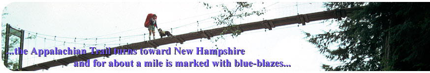
side of Deer Leep Mountain, where I soon found the split between
the Long Trail and the Appalachian Trail. The long trail continues
with white blazes North to Canada, while the Appalachian Trail
turns toward New Hampshire, and for about a mile is marked with
blue-blazes. This is the only part of the A.T. where it is actually
a side trail. The Long Trail is the older trail and therefore takes
priority as the main trail. The white blazes return as the trail
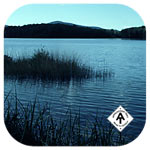
reaches Kent Pond near Gifford Woods State Park just over a mile
beyond. Also near Kent Pond is located Mountain Meadows Lodge, where
a hiker could get a "Bed, Breakfast, and Bath" for only
$6.00! The lodge is used mostly in the winter as a ski lodge, but
during the off season is offered to hikers and bikers at a reduced
rate. I cleaned up and selected my bed in the bunkhouse. I am not
sure, but I suppose that Richard Kozon, a northbounder, also spent
the night in the bunkhouse. There were a couple of southbound thru-hikers
in attendance as well. Twenty-two miles for today.
From
Mountain Meadows on Kent Pond, I called mom and gave her a list
of some items I was in need of for the coming cooler weather. Although
not cold yet, I would eventually need a stocking cap, some gloves,
and more film. And of course more money. I requested the gear and
$150 in small money orders (20's and a maybe a couple of 50's) to
be sent to Gorham, NH farther down the trail. Apparently I had recently
received a notice that I had been called for possible jury duty.
Well, I just could not make it. There was also something about the
arrival of some books on Aug 9th, which may have been the new map
and guides for Maine that were just printed and I had ordered. (notes
from mom) We talked for twenty minutes. (cost $6.95)
Gonzo!
Appalachian Trail Journals ©1983
|