 |
|
|
|
June 3, 1983 Friday (1812.2 mtg) From Gonzo!s Appalachian Trail journal All that long mileage yesterday must have tired us out enough to cause us to sleep in a bit. We got up this morning at 6:30 am. I ate the 20 ounce can of pineapples bought at the Exxon station for breakfast and continued on up the trail with sore leg and all. The pain was not all that bad going uphill, but sore on the way down. The climb up Big Bald was kind of tough, but the rewards of the view from the top made the effort worthwhile. Luckily we did not have to take the side trail that bypasses the summit. This trail is available for use during extremely foggy and rainy weather, and the trail guide recommends its use during this type of weather because extensive open areas such as over the bald cannot be fully marked, additionally it is unsafe to go over an open summit during a lightening storm. The broad, totally treeless, grassy, open summit afforded panoramic, 360 degrees of fantastic view. We propped our packs upon the summit marker and began taking photos. From our vantage point we could see the magnificent country, including Little Bald, that we would be traveling over as soon as we finished our break on Big Bald. We had only gone about six miles by the time we arrived on Big Bald, so lunch would have to wait for a few more miles. We chose not to see what lies at the end of the side trail to High Rocks, probably deciding this after reading in the guide about the trail "leading right steeply." After
descending into Spivey Gap and the roadcrossing at US 19, we temporarily
lost the trail. After an exhausting search of probably less than
a couple of minutes, we decided to see if the occupants in a travel
trailer nearby had any idea where the trail was. We woke up a young
man who was taking a siesta inside. He did not have a clue where
the trail was any more than we did so we continued our search. Soon
we were back on the trail and slopping our way up the ravine that
the trail shared with a stream called Oglesby Branch named after
the first Tennessee Eastman Hiking Club member to have fallen into
it. This hiking club is one of the many that are caretakers of the
trail. Each club maintains a portion of the trail including clearing
blowdowns, building new sections, and keeping the trail open. Some
clubs work harder than others. The Tennessee Eastman Hiking Club
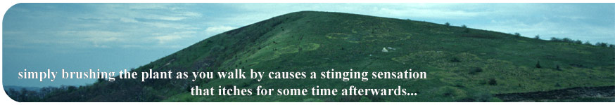
has the tough job of controlling the dreaded stinging nettle populations
along the trail. This is quite a job in North Carolina and Tennessee
where there is a large population of these plants. Stinging nettles
are a menace to the hiker in shorts. Simply brushing the plants
as you walk by causes a stinging sensation that itches for some
time afterwards. In the past the club has gained the reputation
of not clearing these plants from the trail and in 1981, became
known as the Tennessee Eastman S & M hiking club as a result.
Luckily, in this area the conditions are just right for the growth
of another plant known as Jewel Weed that can be crushed and rubbed
on the stinging area of your body and somewhat counteracts the itching
caused by the nettles.
|
