|
June
27, 1983 Monday (1395.1 mtg) From
Gonzo!s Appalachian Trail journal
Had
leftovers this morning! This is quite unusual. The group last night
had so much food that they left me with the remaining potato and
macaroni salad. Good solid food. Life is good! The day started out
with some downhill, but soon went uphill to Thunder Ridge. I felt
lucky that we managed to spend the night without getting rained
on in an area with so many places named "Thunder something."
Two miles of downhill brought me to Petites Gap, where the trail
began a mile and a quarter of uphill to Highcock Knob. From there,
with the exception of a couple of very short uphill sections, the
trail began a descent to the James River almost nine miles away.
Within a mile of beginning the downhill from Highcock Knob, I noticed
that there were no longer white blazes on the trees, but blazes
that were painted brown over the white. This indicated to me that
I was no longer on the current Appalachian Trail, but had somehow
followed the old route. The trail was clear just like a normal trail,
but I had not found Marble Springs as I had expected, so I backtracked
until I found a familiar white blaze, looked around until I spotted
another, and found my way back to the trail. Somehow I had missed
the turnoff while I wasn't paying enough attention. Back on track,
I continued downhill toward the James River.
About four miles farther down the trail I noticed a disturbance
off to the left. Looking toward the sound, I noticed a black bear
as it began running parallel to the trail down the mountain. I dropped
my pack and attempted to get my camera out before the bear disappeared.
The bear was no longer in my site by that time, so I put my pack
back on and walked with camera in hand, halfway hoping that it would
appear again, yet fearing that I would get attacked. I had no
intention of playing Daniel Boone and wooping this bear, skinning
it and eating it for supper - This was a wild bear! Not like those
"wild" bears in the Smokies that are used to human contact.
I felt privileged to have seen it. I walked for some time but never
heard nor caught a glimps of the bear. I did find a viewpoint soon
afterwards where I could see the James River Gorge in the valley
below, and since I already had my camera out…
A couple of miles farther along I came across Matts Creek Lean-to
located on the other side of a ravine with Matts Creek running between
the trail and the shelter. I found a woman named Pat on my side
of the ravine picking blueberries near the trail. Although the shelter
had a picturesque setting and a very tempting "swimming hole"
enlarged near the shelter, I moved on toward the James River.
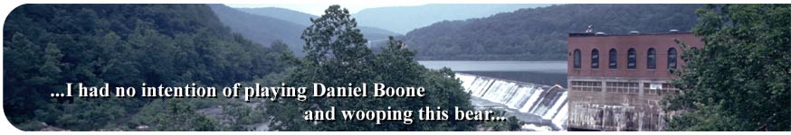
The trail crosses the James River on US 511 on Snowden Bridge via
a narrow sidewalk on the side of the roadbed. The Virginia Electric
Power Company and Dam is located just upstream from the crossing,
and the bridge provides a great view of the facility and the falls
that were created as a result of the dam. The trail climbs away
from the river while it parallels Cashewa Creek for a couple of
miles to John's Hollow Shelter, where I met Jody
Perham, a fellow thruhiker, from Maine. He was traveling along
the Appalachian Trail and at the same time traveling home. I was
impressed by this. He reminded me of the servant in the movie "The
Rocky Horror Picture Show" with his long blond hair and facial
features, and seemed as alien to me as the servant in the movie
turned out to be, particularly after hearing his thick "Down
East" accent. He was funny and I enjoyed his company. We took
a skinny dip in Cashewa Creek near the shelter to cool us down in
the afternoon heat before I set out for the toughest part of the
day - the seven and one half miles of mostly climbing up the area
known as "Rocky Row." The gain in elevation topped out
at almost two and a half thousand feet over seven and a half miles
with only one mile being "level", and maybe two miles
of "downhill." It was known to be tough, but with the
heat and humidity today it would prove virtually unbearable.
The first part of the climb up Rocky Row was about two and a half
miles with a gain of roughly 1500 feet. It had become my habit to
blast up the uphill climbs with no stop if possible, and rest once
at the top. That way the climb was done and I could rest for whatever
was to come after. I blasted up this particular climb with determination
like I never had before. Why? I don't really know. Perhaps it was
because I had heard how tough it was and I was going to prove I
could do it. I certainly had my blood pumping as the climb went
on and on. Sweat was pouring out of my body like gang busters. This
ascent forced me to breath harder than any climb to this point.
By the time I reached the end of this part of the ascent I was so
exhausted that I just took off my pack, lay down on the trail, and
sprawled out spread eagle while laying on my back. The heat of the
day was tremendous. I probably had picked the hottest portion of
the day to do this climb, but hey, I am in the greatest shape of
my life at this time. I am twenty-three years old and have covered
over seven hundred miles of tough up and down trail to get me to
this point. I did it. I rested for only a few minutes. Of course
the entire climb was not over.
From this point the trail dips just a bit and then begins the ascent
again toward the high point on Big Rocky Row about a mile away,
an increase in elevation of about 600 feet. This section turned
out to be not too bad, and I was soon up and over and headed down
a bit toward Saddle Gap. The trail was mostly level for a mile past
Saddle Gap until I arrived at Saltlog Gap and took a good break
before the final ascent up Bluff Mountain. For the next mile and
a half the trail ascended until I reached the wooded summit of Bluff
Mountain where I stopped and sighed, having completed the toughest
section of the trail up to this point. Or was it just the heat that
made the climb so strenuous? Whatever it was, it took the energy
right out of me. Luckily it was all downhill for less than one and
a half miles to Punchbowl Shelter.
I arrived at Punchbowl Shelter to find Pat, the lady I had seen
picking blueberries along the trail earlier near Matts Creek. Somehow
she had gotten ahead of me and arrived at the shelter showing no
signs of fatigue, just a nice chipper attitude. Of course she had
not done the climb that I had just gone over, she had gotten a ride
along the parkway and totally skipped the climb. Some "hikers"
are like that. First thing I did after taking off my backpack was
to jump into the punchbowl! Next to the shelter there is a nice
round pond that was just what I needed after extruding practically
every bit of water from my body on the climb to get here. It felt
reeaaalll gooood! I had traveled twenty-six miles of trail today,
but actually hiked twenty-seven with the little episode of lost
trail adventure earlier. Later Jody and another hiker named Curt
(Tracy?) showed up. I Ate cheese noodles, and pudding for supper.
Slept outside my sleeping bag at least for a while since Pat had
set up a fire and was smoking out the mosquitoes and other insects.
Pat made what she called "pan bread," to eat. She carried
flour, and some other ingredients that when mixed together made
a dough that she "baked" in her pan somehow. Smelled really
good whatever it was.
Gonzo!
Appalachian Trail Journals ©1983
|