|
Sept
1 , 1983 Thursday (253.9 mtg) From
Gonzo!s Appalachian Trail journal
Very
wet trail conditions this morning. Muddy and slippery over the rocks
on the descent from Hall Mountain into Sawyer Notch. The treachery
of the descent only worsened as I crossed over Sawyer Brook and
began the ascent up Moody Mountain. The climb was less than a mile,
but the freshly cut trail that had been rained on the past couple
of days proved a worthy adversary in slowing my progress. The slope
was slick as snot, and I was reminded of the Lynyrd Skynrd song
called "One Step Forward and Two Steps Back." Moody Mountain
remains on my list as one of the worst climbs on the Appalachian
Trail. All the way up with virtually no views, and then when there
might have been a view, I could barely see through the fog. Even
though no rain was falling as I went over the mountain, I was totally
soaked by the time I left from the moisture on the surrounding vegetation.
Following Moody was a two and a half mile climb out of Black Brook
Notch toward the summit of Old Blue Mountain. Old Blue rewarded
me with a cool, wet, foggy, Christmas tree forest toward the top,
and the skies remained obscured by the clouds as I passed over with
still no views other than a grayish white fog. Three miles past
the summit I stopped at Elephant Mountain Lean-to for a quick read
of the register. I gleaned the entries and found out that I was
just behind another hiker that I had not met yet named Tom. Determined
to catch up with him, I set out from the shelter with an excitement
that lead me in the wrong direction. I quickly realized my mistake,
turned around and went back before continuing on toward the ascent
of Bemis Mountain. The Appalachian Trail traveled over an area of
lush moss-covered tree roots, boggy surroundings and amazingly similar
in nature to the rest of the forest surrounding the area. I found
difficulty in following the trail during this section. I managed
to navigate my way through the area and proceeded over the many
peaks of the Bemis Range. By this time the skies had cleared considerably,
and the grandeur of the Maine countryside and Lake Mooselookmeguntic
revealed itself in the valley.
Five
miles of trail over the four peaks of the Bemis Range deposited
me at the banks of Bemis Stream, where no bridge was located to
aid the hiker in his crossing. Directly after skillfully rock hopping
to the other side without falling in even once, I noticed a huge
hornets nest in a nearby tree. I buzzed right on by up the embankment
to Maine highway 17, successfully avoiding any incident. A turnout
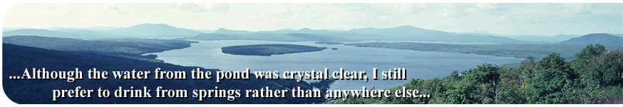
near the trail crossing provided a great view of Lake Mooselookmeguntic.
But for now, my goal was Sabbath Day Pond where I was sure that
I would be able to hear Loons during the evening and possibly see
a moose or two.
After four miles of comparatively easy hiking leading me past a
fairly large pond named Long Pond, I arrived at Sabbath Day Pond
Shelter and began to set up camp. Within minutes of my arrival a
couple of southbound hikers rolled in. One had participated in a
good chunk of the "Hike A Nation" trip from Colorado to
the east coast. He had also hiked other trails. Both of the hikers
were carrying mega food as they had just left the town of Rangely
and were fully supplied. They suggested that I stop at the youth
hostile for the night. We talked for some time and then I walked
back ¼ mile south to a spring that I had seen as I searched
for the shelter. I had not filled up at first pass because I did
not know how far it was to the shelter, and did not want to carry
it any farther than I had too. Although the water from the pond
was crystal clear, I still prefer to drink from springs rather than
anything else. No loons were heard that night, and I did not
catch up to the hiker I was trying to catch. Twenty-one miles for
the day. That is more respectable.
Gonzo!
Appalachian Trail Journals ©1983
|