|
Aug
26 , 1983 Friday (321.2 mtg) From
Gonzo!s Appalachian Trail journal
Got
up early this morning and went to the kitchen to see about getting
some hot water for my oatmeal like I had yesterday morning. When
I asked about it, I was told that I was entitled to eat breakfast
with the rest of the guests before I left. I accepted, ate, and
then packed up for the big climb up Wildcat Mountain. Unfortunately,
the weather had changed overnight, and today I was facing a damp
environment, or at least the potential for a damp climate. The
clouds had rolled in from the west, and Mt. Washington was mostly
obscured by the cloudbank that had just set in over the Presidentials.
So far it had not crossed the valley to the area that I was heading.
The guidebook gave this description for the coming climb: "begin
exceptionally steep ascent; use extra care, particularly when wet."
A mile and a half after engaging in what might be called technical
rock climbing over steep rock slabs, I reached the first summit
of Wildcat. "Peak E" it was called. There is a gondola
terminal building on this summit that if I had really wanted to,
I could probably have sent my pack up by gondola and navigated the
ascent without a pack. I don't like to be separated from all that
I own so I chose not to do that. Besides, that would incur additional
expense as I am sure they would not do it for free. I found the
building closed at this time anyway, so I would have had to wait
for the place to open also. I nfind it best not to slack-pack. I
did manage to get some water at the building, and continued on over
the remaining Wildcat summits. Looking back over toward Mt. Washington
I could no longer see the mountain. Just one big cloud bank.
From the summit of Wildcat I dropped steeply down for .6 mile to
the area known as Carter Notch where I passed a couple of nice mountain
lakes near Carter Notch Hut. I stopped at the hut to check for left
overs, but they had already been cleaned out. Back to the trail
and up Carter Dome I went. While on the way up to the 4832' summit,
the wind began to blow and I decided that I had better prepare for
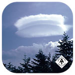
a storm. The wind in this area had produced a lenticular cloud formation
above the mountain that really amazed me, especially when it changed
in shape from a spoon into the shape of a hamburger. I had read
about these types of clouds and felt blessed to have witnessed such
a juicy looking burger.
I put my camera in my pack and began to move quickly to the next
shelter. I had about six miles to go, but only a small portion of
it involved much climbing. I descended off of Carter Dome and found
Zeta Pass then began the gradual uphill climb of Mt. Lethe. From
there it was down hill to Imp Shelter.
I reached the low point in this section where I thought the shelter
was located and began what appeared to be an uphill section. I began
to wonder if I had passed the shelter when I suddenly came across
the A frame structure complete with an upper bunk section besides
the regular floor platform. This was apparently a new shelter since
both the guide and the map called it Imp Campsite. A nice spring/stream
flowed nearby. Found out from a girl at the shelter who was a worker
for the AMC trail crew that she had just reblazed the area around
Garfield that I had so much difficulty finding blazes a few days
ago. A couple of guys from Canada came in later and offered me one
of their dried squids and dried fish. Not bad, but quite salty -
not your typical trail food.
Gonzo!
Appalachian Trail Journals ©1983
|


